SEAFINE
(SEAMOS-South Fine Grid Hindcast) is an Oceanweather
JIP (Joint Industry Project) for development of wind
and wave hindcast on a fine grid of the southern part
of the South China Seas.
In
1992, Oceanweather Inc. produced the JIP known as
SEAMOS (South East Asia Meteorological and Oceanographic
Hindcast Study) designed to provide definitive data
on meteorological and oceanographic extreme and operational
conditions to be used in aid of design of offshore
structures and planning and offshore operations in
the general area of the South China Sea (SCS) and
the immediately contiguous basins. The complexity
of the bathymetry and the relative sparseness of tropical
cyclones in the southern part of the basin presented
some special problems that are addressed in this update
and extension of SEAMOS, which we have dubbed SEAFINE.
This project not only provides an updated and greatly
expanded (in terms of the historical period addressed)
entire southern half of the SEAMOS domain but also
very high resolution metocean hindcasts carried out
with fine mesh nested grids covering the offshore
and coastal resource development areas of interest
to the participants of SEAFINE.
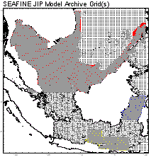
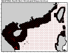
SEAFINE
is based on a uniform grid of 25-km grid embedded
with very-high resolution fine grid nests each with
a grid spacing of about 6 km. The hindcast covers
a continuous period 1956-2015. Over 100 non-tropical
storms (including monsoons) were analyzed by expert
meteorologists. All tropical cyclones were hindcast
using Oceanweather's tropical cyclone mesoscale model
and overlaid into the continuous hindcast. The top
144 influential tropical cyclones were analyzed and
archived separately at a 15-minute time step.
Time
series of wave spectra at over 500 grid points in
total (25-km and fine nests) were archived, exclusive
of the grid points at which spectra were archived
as boundary conditions.